Mixed Layer Depth (MLD)
OceanGraph calculates the mixed layer depth (MLD) from individual Argo float profiles using multiple threshold criteria based on potential temperature (θ), absolute salinity, and potential density (σθ). Potential temperature, absolute salinity, and density are calculated with the Gibbs SeaWater (GSW) Oceanographic Toolbox for accurate thermodynamic calculations.
Accessing MLD
MLD display is available to signed-in users only.
- Sign in and perform a search
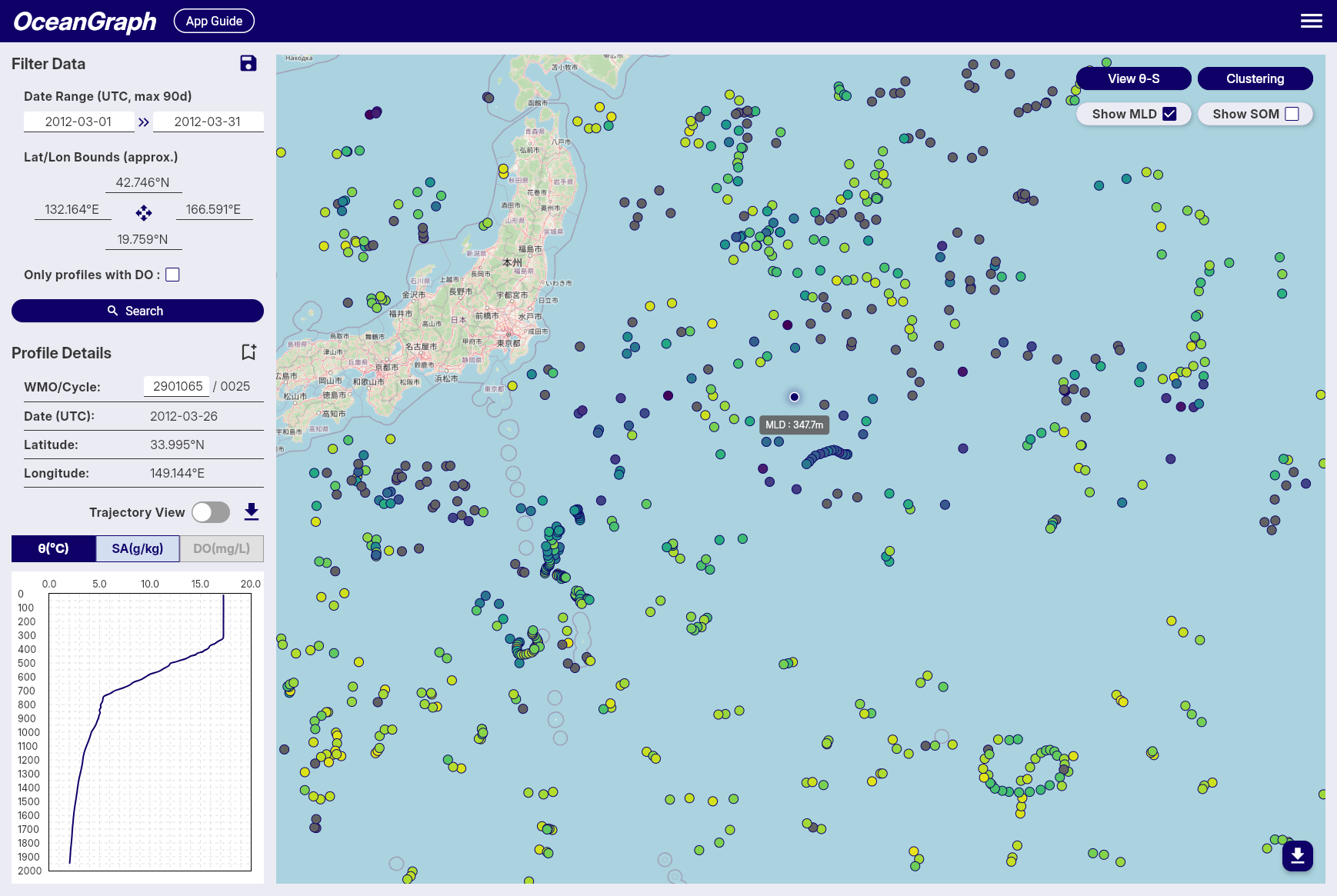
- Open MLD / SOM in the map controls and choose MLD
- Use the marker colors and tooltips to compare mixed layer depth across profiles
MLD, SOM, and mode water map overlays are mutually exclusive. Selecting MLD turns off SOM and mode water coloring. Profiles with missing or undefined MLD values are rendered in gray.
When Trajectory View and the section chart are open, selecting MLD also overlays an MLD line on the vertical section.
Calculation Details
-
Multi-Parameter Calculation
- MLD is determined using three different oceanographic parameters: potential temperature (θ), absolute salinity, and potential density (σθ).
- Potential temperature and density are calculated using the GSW toolbox based on practical salinity, in-situ temperature, pressure, and latitude.
- This ensures high accuracy and consistency in the estimation of stratification and mixed layer properties across different oceanographic conditions.
-
MLD Definition and Threshold
- The MLD is calculated using three different threshold criteria and defined as the shallowest depth among the three methods:
- Temperature threshold (Δθ): Depth where potential temperature (θ) differs by more than 0.5°C from its value at 10 dbar
- Salinity threshold (ΔSA): Depth where absolute salinity differs by more than 0.05 g/kg from its value at 10 dbar
- Density threshold (Δσθ): Depth where potential density (σθ) differs by more than 0.125 kg/m³ from its value at 10 dbar
- This multi-parameter approach provides a more robust estimation of the mixed layer depth by considering both thermal and haline stratification.
- If no depth is found using any of the three criteria, the MLD is considered undefined for that observation.
- The MLD is calculated using three different threshold criteria and defined as the shallowest depth among the three methods:
-
Data Quality Requirements
- Reference Depth Coverage: The shallowest observation must be no more than 20 dbar deeper than the reference depth (10 dbar). If this condition is not met, or if the reference depth is deeper than the deepest observation, MLD calculation is skipped for that profile. When the shallowest observation is within 20 dbar of the reference depth, the shallowest observed value is used as the surface representative value for the MLD calculation.
- Shallow Data Availability: A minimum of 2 data points at or above 50 dbar is required for reliable MLD calculation. Profiles with insufficient shallow measurements are excluded from MLD computation to ensure accuracy.
-
Conversion to Depth
- The estimated MLD (in decibars) is converted into physical depth (in meters) using a latitude-dependent algorithm from the UNESCO 1983 standard.
- This conversion allows MLD values to be spatially visualized or regionally compared using consistent units.
-
Color Representation
- For visualizations such as maps, MLD values are mapped to colors using the cmocean
deepcolormap. - Profiles with missing or undefined MLD values are rendered in gray.
- For visualizations such as maps, MLD values are mapped to colors using the cmocean
This approach provides an accurate and robust estimation of mixed layer depth across a wide range of Argo float profiles by utilizing multiple oceanographic parameters. The multi-threshold method ensures that the MLD estimation captures both thermal and haline stratification effects, making it particularly well-suited for visual analysis and regional comparisons in diverse oceanographic environments.